Saturday, June 22, 2013

Wild Western Rodeo in Wisconsin

 
Stanley Rodeo Days is always held the weekend of Father’s Day, and this was the first year that we were going to finally make it.  Stanley WI is about an hour’s drive east from our home.  We pulled out our cowboy hats, boots and western shirts and packed up some food and drinks for the day.  Now that we are both retired we are making time to enjoy events, so we were pretty excited.
Maybe you too will learn something that you didn’t know about this sport.  Enjoy!

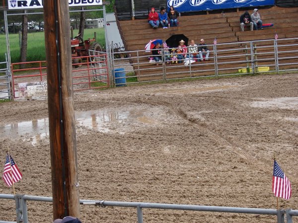
The arena with about 3 inches of mud to play in

Dodge Ram, the major sponsor

Bareback Bronc Riding
The rider begins his ride with his feet placed above the break of the horse’s shoulder.  If the rider’s feet are not in the correct position when the horse hits the ground on its first jump out of the chute, the rider is disqualified


A "hazer" in action helping a rider off his horse
Through the 8 second ride, the rider must grasp the rigging (a handhold made of leather and rawhide) with only one hand.  A rider is disqualified if he touches his equipment, himself or the animal with his free hand.  He is judged on his control during the ride and on his spurring technique.  The score also is based on the rider’s “exposure” to the strength of the horse; therefore, the horse’s performance accounts for half the potential score.
Calf Roping
Like bronc riding, calf roping is an event born on the ranches of the Old West.  Sick calves were roped and tied down for medical treatment.  Today, the luck of the draw is a factor.  A feisty calf that runs fast or kicks hard can definitely foil a roper’s finest efforts.  The calf is given a head start, horse and rider give chase.  After roping the calf, the rider dismounts and runs to the animal.


 After catching and flanking the calf, the rider ties all four of the animal’s legs together using a “pigging string” he carrier in his teeth until needed.  Once completed, the rider throws his hands in the air as a signal to the judge.  He must then remount his horse and allow the rope to become slack.

Saddle Bronc Riding
Rodeo’s “classic” event has roots that run deep in the history of the Old West.  Ranch hands would often gather and compete among themselves to see who could display the best style while riding unbroken horses.  It was from this early competition that today’s event was born.


 Each rider must begin his ride with his feet over the bronc’s shoulders to give the horse the advantage.  Spurring action begins with the rider’s feet far forward on the bronc’s point of shoulder, sweeping to the back of the saddle, or “cantle” as the horse bucks.  The rider then snaps his feet back to the horse’s neck a split second before the animal’s front feet hit the ground.
Disqualification results if the rider touches the animal, himself or his equipment with his free hand, prior to the buzzer which sounds after 8 seconds.
 
Bull Riding
Upper body control and strong legs is the key to riding bulls.  The rider tries to remain forward or “over his hand,” at all times.  Leaning back could cause him to be whipped forward when the bull bucks.  Judges watch for good body position and other factors including use of the free arm and spurring action.  Although not required, spurring will add points to a rider’s score. 

Rider Down!!!

All I can say is, are they crazy?
Other events that were way too fast to snap a good picture for you. . .
Steer Wrestling
The steer wrestler on horseback (also known as a “bulldogger”) starts behind a barrier and begins his chase after the steer has been given a head start.  The bulldogger is assisted by a “hazer” - another cowboy on horseback tasked with keeping the steer running in a straight line.  When the bulldogger’s horse pulls even with the steer, he eases down the right side of the horse and reaches for the steer’s horns.  After grasping the horns, he digs his heels into the dirt.  As the steer slows, the rider turns the animal, lifts up on its right horn and pushes down with his left hand in an effort to tip the steer over.  The clock stops when the steer is on his side with all four legs pointing the same direction.
Team Roping
This event grew out of the ranch chores of the past.  Larger cattle would have to be immobilized for branding and doctoring by two ropers due to their strength and size.  Today, team roping is a timed event that relies on the cooperation and skill of the cowboys and their horses.
Two riders are involved in team roping.  The first, known as the header, ropes the head of the cattle and the other rider, known as the heeler, ropes the heels or legs.  Once the catch is made and all completed the clock stops when there is no slack in both ropes and the horses face each other.  Team work is the key to its success and so much fun to watch.
Clown/Barrel man
I don’t think we need to say much on what they do…making the rodeo so much more fun to watch.  They do an amazing job at distracting an angry bull once he’s thrown his rider into the dirt, or just plan entertaining the audience.  They are wonderful!
 
What's a rodeo without the clown?

Amateur Barrel Racing
The horsemanship skills and competitive drive in this fast and furious event definitely draws the crowd participation.  First of all, the contestant enters the arena at full speed on a sprinting American Quarter Horse.  They start the pattern which triggers an electronic eye that starts the clock.  The racer rides a cloverleaf pattern around 3 barrels and sprints back out of the arena, tripping the eye and stopping the clock as the horse and rider leave.


A future rider!
Boot Scramble
What’s an event without getting the kids in the audience involved?
All of the children participating take off their footwear and walk to the middle of the arena.  Here they deposit their shoes and then walk back to a starting line, where once they are given a signal, they run to the shoe/boot pile and try to find theirs.   First one to get back gets a prize!  Watch out for the mud!!!!!

Okay, so now where is my other shoe....I see it!!!
 
The special flag ceremony by the FFA and Stanley HS football team for a local, fallen Cowboy.
Bringing out the American Flag
The Flag extended. . .quite a sight

The fallen rider's horse

Cowboy’s Prayer
Heavenly Father, we pause, mindful of the many blessings you have bestowed on us.  We ask that you will be with us at this rodeo and we pray that you will guide us in the Arena of Life.  We don’t ask to draw around a chute-fighting horse or to never break a barrier.  Nor do we ask for all daylight runs or not to draw a steer that won’t lay.  Help us, Lord, to live our lives in such a manner that when we made the last inevitable ride to the country up there, where the grass grows lush, green and stirrup high, and the water runs cool and deep, that you, as our last judge, will tell us that our entry fees are paid.     ~Amen 
 
Other fun sights. . .


"Beer Here" vendor wearing funny hats

These cowboys jut got new pistols from Grandma to try out


Little Adel, who captured our hearts in the bleachers.


Hugs to all.
Kay & Jeff

Thursday, June 6, 2013

Our Continuing Journey Through Texas

Dateline:  April 15:  The anticipated date to leave the RV park in Edcouch, Texas (elevation 75 ft.) to return to our home in Wisconsin.  But, because of the inclement weather still persisting in the Midwest, we now have set our sights on heading toward the areas of North Texas known as the Hill Country.


Day 1 & 2:  We traveled about 176 miles taking us to Three Rivers, TX where we stopped at Choke Canyon State Park.  This state park is a 26,000 acre reservoir that is regarded as some of the finest fishing in Texas.  Unfortunately, we did not partake of this tidbit so made the most of just relaxing and enjoying the scenery and wildlife.   Jeff checked with his brother back home and after hearing that winter was still horrible, we decided to take a major detour and head for Big Bend since we were so close.  This was the best decision we could have made…..so here is our journey getting there, being there and then hitting the road (finally) in the direction of our stick built home.  I guess you could say that we were headed to Texas’ “Wildest West” . . . so hang on to your hat for our ride!

Luckily, we did not see one!

Just one small piece of the reservoir
 
Day 3:  We both got our fill of seeing the many oil fields through this part of Texas.  It seemed like anywhere you looked you would see signs, “RV spaces for rent” where the workers lived – no grass anywhere – only fields of dirt available for their homes.  Just a very different way of life for the oil rich land that was everywhere we looked.  It was good to drive out of that as we arrived in Del Rio, TX (home of Laughlin Air Force Base) early pm that day.  We picked up a few groceries at the HEB and a delicious BBQ sandwich in town.  Our direction was headed toward Lake Amistad (“friendship” in Spanish) National Recreation Area which lies on the US-Mexico border.  This reservoir (total length = 6.06 miles) was created for flood control, water storage, power generation and recreation in 1969 and is operated and maintained jointly by the US (1.81 miles in the US) and Mexico (4.25 miles in Mexico).  Because of the lingering drought in Texas we have learned that Lake Amistad is currently 53 feet below it’s expected level; elevation 1,117 ft.   Enjoying Amistad from the many areas available within this recreation area can be overwhelming.  The National Park Service operates five campgrounds, so after checking out a couple of places, we settled on the area called, Spur 406, which was very remote and beautiful -we were the only ones there- and at $2/night (orig. $4/night but discounted with Jeff’s Senior Pass), who could argue the price!


This was a common sight along this stretch of road
 
Our site for the night at Spur 406 in Lake Amistad
 
The US side of Lake Amistad
 
Day 4:  Pulling out of the campground at 9a. for what we thought was going to be a fairly light day of travelling was suddenly stopped.  Within a half hour we discovered that we couldn’t find one of our cats, Chuck….ANYWHERE….in the RV.  I guess what I should say is that we thought we knew of all of the hiding places that the cats could sneak into, but we know better now.  Thinking the worse that for some reason he had escaped outside, we spent most of the day outside looking for Chuck.  It really was a day from Hell.  At about 6p Chuck appeared from his new hiding place (HURRAY!!!), and thus, we were on the road again but mentally exhausted to really travel any length of time.  We pulled into Langtry, TX – a little RV park that had full hook-ups for $20.  It was a welcomed sight for us as we knew that we were going to be entering some very exciting country with some higher elevations and so awesome landscape.  Langtry boasts, “The Law West of the Pecos” during a time when the West’s most colorful justice of the peace, Judge Roy Bean, ruled America’s last frontier in the last decades of the 19th century.
We were camped for the night just adjacent to the Post Office

Day 5:  It was good to sleep in as we pulled out of Langtry around 10:20a.  We had already traveled 475 miles and we knew that we needed to fill up with fuel before getting to Big Bend so we pulled into the cute little town of Sanderson, TX to feed the RV (big time!) and then travel the 93 miles to the town of Alpine, TX.  Here we would head southward to the towns of Study Butte & Terlingua near Big Bend National Park's west entrance. 

We were getting excited seeing the mountains!

Terlingua & Study Butte

These towns were founded at the turn of the 20th century as mining towns with the discovery of cinnabar (from which the metal mercury is extracted).  Terlingua attracts a hodge-podge of artists, bohemians and musicians . . . so we decided to hang our hats at BJ’s RV Park.  Terlingua became a ghost town after quicksilver markets dried up and the mines closed in the 1940s.  Two decades later, “chili-heads” began making an annual pilgrimage each fall for the Terlingua International Chili Championship. 


Our first Jeep trail ride - Yahoo!

More awesome mountain views to marvel at

Our Jeep "buddies", Pat & Larry, from Hayward WI

Back on the dirt trail...loved it!

Two rock boulders - kissing!!!!!
More scenery on our Jeep trail


10th Annual Chihuahua Dog Races

View of the Chisos Mountains from the Ghost Town on race day

Good times with good friends!


Sign adjacent to BJ's RV Park where we were camped

Jeff calls this the "redneck" BBQ

A truly beautiful sunrise at BJ's RV Park
 
Camino Del Rio – The River Road

Hwy 170 along the Rio Grande where at certain places the road becomes narrow, winding and very steep, making it difficult for some RVs, busses and trailer rigs, is certainly a unique road that we took from Study Butte to Lajitas to Presidio.


The Rio Grande River off to the left
From all of the Jeep rides we needed a car wash...why not the Rio Grande!
 
Is this what they call "King of the Moutain"!
 
Some very unique rock formations along the drive
 
This was one of our favorites
 
Some pretty magnificent mountains

Contrabando ~ Big Bend Ranch State Park

This ghost town is within Big Bend Ranch State Park, 5 miles west of Lajitas on Hwy 170.  Since 1985, the site has been used as a set for 9 movies including “Lone Star”, as well as “Dead Man’s Walk” and Streets of Laredo”, which were part of the Lonesome Dove miniseries. 

Can you tell which one was the Church?

The Saloon.....of course!

A surprise up in the rafters of the Saloon - a family of swallows.

Big Bend National Park

Named for the huge sweeping curve of the Rio Grande, this park covers 800,000 acres accessed by 200 miles of primitive trails, 112 miles of paved roads and more than 150 miles of dirt roads (ahhah….this is where the Jeep was very instrumental).  The park lies within the Chihuahuan Desert and the high point of any visit to the park is the Chisos Mountains Basin – the main hub for hiking treks ranging from short and easy to steep and tough.
 
Walla - the entrance to the park!


The road that takes us to Casa Grande (The Big House)

Late 1800s ranch through the eye of the camera's zoom

Here is that same ranch at the base of the mountain

"Mule Ears" Mountain

Quite a unique rock formation

Another rock that looks like it has trees branches growing in it

Kay taking a break - probably has a pebble in her shoe.....imagine that!

The beautiful Santa Elena Canyon affords float trips for kayaks, canoes & rafts

Cinnabar Mining town built into the mountain - late 1880s

Another example of the earth plates pushing up through the surface
Awesome rock formation


At mid afternoon, here is a look at the smog from our pollution

The Window Trail

Of all the trails in Big Bend, the Window Trail is the most popular and is considered a must.  The Window Trail descends 980 ft. over 2.8 miles one way and ends at the famous “Window,” a narrow slot canyon providing a glimpse of the desert far below.  On a clear day you can actually see BJ’s RV park but we had a very hazy sky. At Panther Junction park services building we saw pictures of clear to very smoggy skies. The smog is being blown in from Mexico and east Texas.

Who is that fellow taking a much needed rest?

The "Window" from quite a distance

The "Window" up and personal with Kay - what a trip!

Some of the hiking trails that we encountered

 
Hot Springs Historic District

About 2 miles off the main road of Big Bend, is the abandoned resort called Hot Springs, a place that was all the rage in the 1920s.  The drive down turns to white, powdery sands. The rest can be seen on foot.  Out of nowhere appears a long-abandoned, whitewashed stone structure that was the post office for many years and functioned as a concession until 1952.  When the river is low, those 108 degree waters still soothe tired bones.
 
The entrance to the Hot Springs - awesome!

The back view of the Post Office - stamps, anyone?

The Post Office/Store from the main parking lot

 
Plants of the Chihuahuan Desert

The succulents, wildflowers, shrubs and trees were a beauty to behold in this high desert environment.  Even though we were seeing some of the cacti at its early stages of blooming, it was still quite the experience of color.  Enjoy some of the pictures that we were able to snap and share with you.  We definitely fell in love with this area and plan to go back!
 
Blind Prickly Pear

Prickly Poppy

Havard Agave - in the early stages (lives 25 years)
Havard Agave (after it finally flowers)


Tree Cholla

Indian Paintbrush

Thompson's Yucca

Purple Prickly Pear
Unidentified wildflowers that were plentiful

Candelilla (used in women's lipstick)

Ocotillo (my favorite!)


Desert-willow tree - very sweet fragrance

Dog Cholla
Marfa

It is written that for more than 100 years mysterious lights have appeared on the outskirts of town; therefore, dubbed the “Marfa Lights”.  This unexplained phenomenon draws thousands of travelers annually.  The lights appear over the former site of Marfa Army Air Field, a WW II flight training base, but not everyone sees them.  We unfortunately, were not lucky the evening that we went…..and who can really take a good picture of nothing when it’s dark!  It was a fun evening anyway as we met up with some good friends, Pat & Larry, that were there too.


Days 6 thru 16:  It was sad to leave all of the wonderful friends that we met in Terlingua, and most of all the beautiful mountain scenery.  Next stop on the agenda was Fort Davis (elevation 4,900 ft.) and the McDonald Observatory (elevation 6,240 ft.).

Prude Ranch (founded in 1897)

Our campsite at this working ranch has been open to guests since 1921 and offers bunkhouse and motel-style lodging, horseback riding, etc. and plenty of ranch-hand chow. 
 
Quite nice being the only ones here

Day 17:  An old-fashioned Cherry Coke fountain drink that Jeff and I grew up on at the Fort Davis Drug Store brought back so many memories for both of us growing up during that era when life was simpler and there weren’t so many choices.  In the evening we drove up the Fort Davis Mountains to attend a Twilight Program and Star Party that covered the constellations, planets and interactive activities in their outdoor amphitheater where we were able to view Saturn’s rings through one of the large telescopes.  Did you know that it takes approx. 45 minutes for your eyes to adjust to the darkness before you can actually see all of the stars in the sky?  We definitely felt very small.

What fun we had at the drugstore

Fort Davis National Historic Site

Fort Davis was one the most important posts in frontier defense in the late 1800s, located along the San Antonio-El Paso Road.  The fort protected emigrants, freighters and mail coaches from raids by Apache and Comanche Indians in the area.  Starting in 1867, the fort was home to four companies of the 9th US Calvary – African-American soldiers that became known as “Buffalo Soldiers”. 

Jeff trying to catch a ride!
Just one view of the Fort
 
McDonald Observatory

Thirteen miles west of the 2,700-acre Davis Mountains State Park, we were able to look to the stars at the University of Texas’ McDonald Observatory.  This research and educational facility is named for a Texas banker who provided funding for the original 82-inch telescope built in 1933.  A world leader in astronomical research, the Observatory sits atop 6,800-ft Mount Locke and features a 107-inch telescope for some of the darkest night skies in the nation.  This was truly a WOW kind of experience.


Day 18:  Before leaving Fort Davis our odometer tells us that we have already traveled 816 miles since leaving the RV park on 4/15.  We head out and notice that it is a pretty windy day for driving so we plan on driving to Sweetwater, TX where we stay the night on a side road outside of a Walmart (no RV parking allowed here) just to get out of the thunderstorm that is brewing.  A very noisy location but at least we are off the road for now.

Day 19:  Not a very good night of sleep but we head toward Abilene, TX where we pull into a Flying J. for diesel, breakfast and an extra cup of coffee.  Jeff drove 279 miles to the Visitors Center in Oklahoma and from there we pulled into a Good Sam RV Park in Marietta for the night.  Kay saw a cougar (yes, a COUGAR…here kitty, kitty) so that was pretty cool, and this campground had the BEST water pressure we’ve had for many a day. 

Day 20 & 21:  Another travel day getting through Oklahoma (3.5 hours) before getting to the Kansas border.  We arrived at the first Visitor’s Center to determine that our next destination was going to be the El Dorado State Park (about 40 miles from Wichita) where we would pull in to stay 2 nights.  This state park is located on the edge of the scenic Flint Hills and is considered Kansas’ largest state park, covering approx. 4,000 acres with 1,100 campsites this reservoir is huge.  At this time of the year it was pretty quiet…but so relaxing.


Day 22:  Time to hit our next state – Missouri!  After driving 513 miles since our last diesel fill we stopped for fuel in Columbia, MO and then to the Pine Tree RV Park not too far from there just to get a good night’s sleep.

An American Barn Quilt, first spotted in Missouri


Day 23 thru 25:  Next destination – Iowa.  We thought it would be good to do some fly fishing in the many trout streams in Decorah, Iowa.  Jeff has a friend that he fly fishes with in Wisconsin that grew up in Decorah, so he gave us some information and the rest was history.  We stayed at the Pulpit Rock Campground as our playground for these last days where the picturesque limestone bluffs and rolling hills are home to plenty of great trout fishing, hiking and biking trails.  We are already talking about our next trip to Decorah for more fishing.  The trout streams are fantastic!
We were able to find more quilts in Iowa
Barn Quilt on a church outside of Decorah

Pulpit Rock Campground - a very nice place to call home for 3 days

North Bear Creek.....here fishy, fishy.....

South Bear Creek

Arrived in Wisconsin on May 9, so we are in Wisconsin.....for now!
 
Note to our followers:  Taking over 300+ pictures tells the story of our trip back to the Midwest, so we hope that you have enjoyed some of them that we have shared with you.  There are so many good ones that it was really hard to pick out the ones to post with our Blog.  It was quite the memorable adventure. 

Hugs to all.
Kay & Jeff