Driving around Phoenix went
well. With any big city you definitely
run into more traffic. The interstate
roads here are beautifully kept and are quite scenic. Take a look at what Kay snapped with the
camera on how beautiful these roads are kept by ADOT.
We finally arrived in Apache
Junction, Arizona (40 miles east of Phoenix) home of the Superstition Mountains
– said to be the second most photographed and painted natural landscapes in
Arizona after the Grand Canyon. This
range of mountains spreads across 250 sq. miles here in the Sonoran Desert. Popularly called “The Superstitions” (for unexplained
paranormal stories) they majestically look down over the Lost Dutchman State
Park where we parked the motorhome.
 |
| Superstition Mountains |
 |
| Our site at the State Park |
On our first night here
Jeff’s cousin and her husband, Carol &
Dale had us over for a
delicious pot roast dinner with all of the fixings. Dessert was strawberry shortcake! Carol set an absolutely beautiful table for
us. The evening was perfect catching up
on what each of us have been doing.
Carol had a folder of information already compiled for us to check out
in the area of things to do. With that
in hand our second day was the start of a jeep trip that we will not forget, so
hang on to your seats for this ride!
 |
| Carol and Dale |
We started on our next
morning exiting the entrance of the Lost Dutchman State Park in the Jeep, and it is here
that we entered the Tonto National Forest.
Right away we start navigating its climbs, twists and turns on what is
named the Apache Trail. You do not take your home on wheels on this trail. . .believe me! They say that this trail once served as a
stage coach/freight route and also for building materials for the Roosevelt dam
and where Indians, cowboys and miners roamed the mountains. It’s hard to believe that humans could endure
this diversity of landscape through these breathtaking canyons.
 |
| Taken from the driver's side. |
About 10 miles in we see the
first natural lake on this route. It is
Canyon Lake. Nearby a popular tourist
spot for food and souvenirs is Tortilla Flat, but most people don’t venture too
far beyond this location. After 5.5
miles the pavement ends and the beginning a 24-mile stretch of graded gravel -
washboard bumpy – road awaits us. The
trail at this point takes you through some near pristine open country such as
Fish Creek Hill with a nearly 8% grade (no RV’s here!).
 |
| Canyon Lake |
Passing a second desert
lake, Apache Lake on our left, we continue to cross numerous foothills before
reaching the beautiful Salt River.
 |
| Apache Lake |
 |
| Apache Lake from the driver's window |
 |
| One Lane Bridge ahead! |
 |
| Areas for a boat launch - can you believe it? |
 |
| Tortilla Flat in the distance. |
 |
| The pavement ends ~ dusty road ahead! |
Another 13 miles from this
point - more dusty, gravel roads – we reach the beautiful waters of Lake
Roosevelt and the Roosevelt Dam.
Directly from there the spectacular bridge appears that was built to
take traffic off the top of the dam. It
is quite a beautiful structure.
 |
| Yes, I do believe we need to turn right! |
 |
| One lane roads along the canyon. |
 |
| We're going where below...on what road? |
 |
| More one lane roads - awesome! |
 |
| This vista point is a beautiful shot of the Salt River |
 |
| The road parallel with the Salt River |
 |
| The Roosevelt Dam in the distance. |
 |
| Roosevelt Lake ahead with the new bridge. |
 |
| Roosevelt Lake |
 |
| We headed South so we did not cross this bridge. |
South of the Roosevelt Dam
we head toward the mining towns of Globe and Miami founded in the
mid-1870s. First started as gold mines but
turned into silver/copper mines with 97% copper and the remainder 3% of gold,
silver and other precious metals.
 |
| But first. . .two descents of 7% grades! |
 |
| Hang on!!! |
 |
| The diversity in the landscape is beautiful! |
We headed toward the town of
Miami. Climbing to an elevation of 1200 ft.
over the Pinal Mountains we reached 4600 ft. and then started the decent
through Devils and Queen Creek canyons where we arrive at a spectacular steel
arch bridge.
 |
| The booming town of Miami, Arizona |
 |
| Large Mining area outside of Miami, AZ |
 |
| The Mine from the distance. |
 |
| Such diversity in the rock formations |
 |
| Heading down and through the tunnel we go! |
 |
| The steel bridge in the distance |
Superior is about 3 miles
beyond where we start our descent to the Salt River Valley through Florence
Junction. From there we continue back to
Apache Junction after a fantastic trip.
All in all – about 130 miles!
 |
| Clouds moving in for a few raindrops! |
 |
| What a trip - what scenery! |
As we begin to wind down our
days here in the Apache Junction area, we have been able to enjoy our time with
family – kind of getting reacquainted with family that we hardly ever see. We enjoyed delicious pizza (with
entertainment) at Organ Stop Pizza in Mesa.
The uniqueness of this restaurant is where the mighty Wurlitzer theatre
pipe organ reins “king”. This isn’t your
normal pizza eatery. 43-foot ceilings
provide unbelievable acoustic sounds: “The massive quantities of wind required for
operation are provided by four huge turbine blowers. The resulting instrument boasts 78 ranks, 17
tuned percussion and innumerable traps and effects and is the largest
Wurlitzer in the world.” The hidden organ rises on an 8,000 lb.
rotating hydraulic elevator and every 20 minutes musical selections are played
for the audience. One of Kay’s favorites
was music from the Phantom of the Opera.
It was quite the musical performance that we have never heard and will
definitely remember.
 |
| What a show at Organ Stop Pizza |
Basha is a large grocery
chain in this area of Arizona (similar to the HEB grocery chain that we loved
so dearly in the Rio Grande Valley in Texas last year). Basha’s corporate office is in Chandler,
Arizona so together with Jeff’s cousin, Carol and her husband, Dale, it was
again time for another road trip. It is
at this location that we enjoy an art collection which Eddie Basha opened in
1992 in memory of his Aunt Zelma. This
art collection of over 3,000 pieces consisting of all mediums of paintings,
drawings, bronze, wood and natural stone sculptures, wood-turned bowls,
basketry, pottery, katsinas (Hopi Indian religious spirits) and jewelry – called
the Zelma Basha Salmeri Gallery of Western American & American Indian Art.
 |
| So many Pima and Hopi baskets to look at |
 |
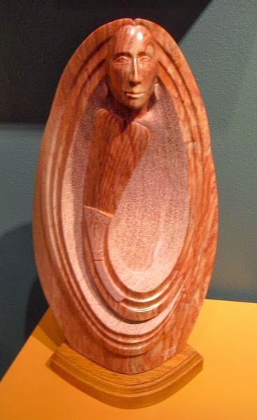
| Sculpture made of cottonwood |
 |
| We always seem to be drawn to the "horses". |
 |
| Corals and turquoise |
 |
| Such beautiful detail on the pottery pieces. |
 |
| Marble sculpture |
 |
| Jeff and Dale checking out the guns! |
 |
| This was Kay's favorite! |
 |
| Kay and Carol |
Note: This update is long
overdue but due to the fact that we are boondocking at the north entrance of
Lake Pleasant Recreational Area, we do not have an active 3G or 4G service
because of being so remote. Therefore,
we are posting this from the parking lot at the Park’s main entrance. We still have phone service and that’s okay –
no need for satellite TV where we are.
Our next blog will let you know what we’ve been up to here at Maricopa
County’s, Lake Pleasant Recreational area – about 35 miles from Phoenix. Shhhhhhh….for those of you that are back in
“cold USA/Canada, we are here enjoying wonderfully warm temps here. We’d be crazy to head back home if we don’t
need to right now.
 |
| Currently, our back yard at Lake Pleasant |
Hugs to all ~ Kay & Jeff